Logo-GOHSC-Blanco-1

Goals and Facts

Goal of the Observatory

The goal of the Global Observatory of Healthy and Sustainable Cities is to provide comparable spatial and policy indicators of healthy and sustainable urban design and planning for cities across the globe. 

The indicators used in our observatory rely on evidence-based benchmarks, and will allow tracking progress for attaining cities that, by design, maximize people’s health and wellbeing, whilst contributing to climate change mitigation.

Facts about the Observatory

The first iteration of the Global Observatory of Healthy and Sustainable Cities:

  • Was launched in May, 2022, after the launch of the 2022 Lancet Global Health Series on Urban Design, Transport and Health.
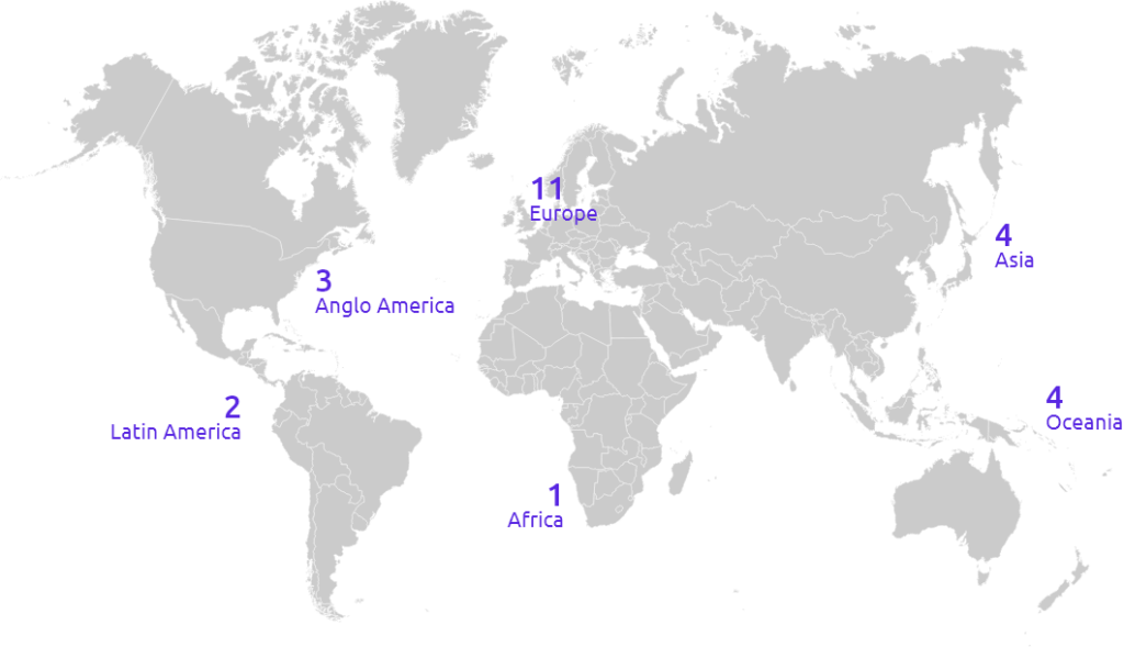
  • Is the result of over 3 years of global, collaborative research, by a team composed of over 80 investigators, from 34 institutions, based in 25 cities in 19 countries and 6 continents.
  • The study was overseen by an international, 12-member Executive Committee.
  • Includes 25 cities located in 19 countries and in 6 continents (all but Antarctica).
  • Relies on evidence-based benchmarks, supported by extensive and rigorous research.

The 25 cities that provided the first cohort of data for the Global Observatory of Healthy and Sustainable Cities are shown in the map below:

We expect to grow the Observatory to include indicators for more low and lower-middle income cities in the near future!

For each of the 25 participating cities, the observatory provides spatial and policy indicators to assess healthy and sustainable urban design and planning, which are summarized in easy to use tools for advocacy and policy action: Scorecards and Reports.

10

Plan periodic reassessments to monitor progress

Your team can continue to work together to advocate for progress and serve as a resource for city leaders.

Repeating the calculation of indicators every few years provides occasions to celebrate progress, identify continuing, and update goals.

9

Present results to city leaders & build consensus for an improvement plan

You are now ready to organize one or more meetings or events to present results to city leaders and encourage their use in setting goals to improve policies and environments in your cities.

It is useful to have people from multiple sectors involved in the presentations.There are recordings of local events in which indicators are presented to city leaders on the website.

8

Submit your data, Scorecard, and Report for inclusion on the Global Observatory of Healthy and Sustainable Cities website

Send your city’s finalised Scorecard and/or Report to info@healthysustainablecities.org, for upload to the Global Observatorywebsite.

Your city will officially be included in the 1000 Cities Challenge, and city teams will become part of our Global Healthy and Sustainable City-Indicators Collaboration.

7

Compute spatial and policy indicators using the Global Healthy & Sustainable City Indicators (GHSCI) Software

Check your data and indicator results to ensure they are as accurate as possible. Validation checklists and the Global Observatory team will assist with validation.

Please contact our team for support: info@healthysustainablecities.org

6

Compute spatial and policy indicators using the Global Healthy & Sustainable City Indicators (GHSCI) Software

Use the GHSCI Software to:

  • Configure and analyze spatial data
  • Upload the Policy Checklist for analysis
  • Generate indicator outputs (e.g., maps, summary reports for validation and comparison)
  • Please contact our team if you require support using the GHSCI Software

Policy indicators include:

Metropolitan transport policy with health-focused actions

Air pollution policies for transport and land-use planning

Requirements for public transport access to employment and services

Employment distribution requirements

Parking restrictions to discourage car use

Minimum public open space access requirements

Street connectivity requirements

Provision of pedestrian infrastructure and targets for walking participation

Provision of cycling infrastructure and targets for cycling participation

Housing density requirements

Minimum requirements for public transport access and targets for public transport use

Publicly available information on government expenditure for different transport modes

Spatial indicators include:

Population with access to fresh food market or supermarket

Population living in neighbourhoods above minimum density threshold for WHO physical activity target

Population with access to regularly running formal public transport (<20 mins)

Population living in neighbourhoods above the median walkability across cities

Population living in neighbourhoods above minimum connectivity threshold for WHO physical activity target

Population with access to any public open space

5

Collect data

Policy data

  1. Identify the relevant level(s) of government for your analysis, and the government sectors responsible for the policy areas covered in the Policy Checklist.
  2. Conduct a search of government or public websites and repositories to identify relevant policy documents.
  3. Find and enter relevant policy details into the 1000 Cities Challenge Policy Checklist.

Spatial data

  1. Confirm the existence of the required spatial data.
  2. Download data for analysis of your urban area.
DataPurposeRequired
OpenStreetMapOpenStreetMap .pbf file with coverage of the region (and time) of interest; this could be an historical planet file, or a region-specific excerptYes
Population GridsPopulation distribution raster grid or vector data with coverage of urban region of interest. GHS population grid (R2023) is recommendedYes
Region BoundaryVector boundary for identifying study region (e.g. geopackage, geojson or shp).Conditional
Urban RegionGlobal Human Settlements Layer Urban Centres database and/or administrative boundary for urban region of interestConditional
Transit FeedsCollections of zipped GTFS feeds to represent public transport service frequencyNo
OtherOther custom data, such as points of interestNo

Further information and guidance on how to collect policy and spatial data is available on the Global Observatory website, Resources tab

4

Seek advice from country/regional mentor

The Global Observatory team, including country/regional coordinators can act as mentors or guides and will be able to answer questions related to the data collection plan, policy and spatial indicators computation, and generation of the Scorecard and Report.

3

Generate a Data Collection and Analysis Plan

  • Download and familiarize yourself with the Policy Checklist.
  • Review the steps for the Indicators Software available from the Global Observatory website, Resources tab.
  • Develop a policy data collection plan and identify who will collect the data.

2

Attend or watch an information and/or training session